Creating Accurate and Effective Airport Maps with GIS Technology
What is Airport Mapping ?
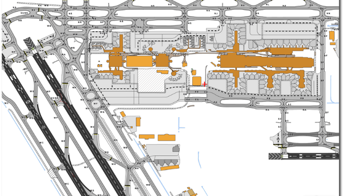
Airport Mapping refers to the process of creating detailed maps of airport facilities, including the runway, taxiways, terminal buildings, and other structures and features. These maps are used for a variety of purposes, including airport planning and design, navigation, and emergency response.
Key factors to consider that go into creating an effective airport map which includes:
- Scale: The scale of the map should be appropriate for the intended use. For example, a map used for navigation purposes may need to be more detailed than a map used for overview or planning purposes.
- Accuracy: The map should be as accurate as possible, with all features and structures depicted in their correct locations.
- Clarity: The map should be easy to read and understand, with clear labels and symbols.
- Up-to-date: The map should be kept up-to-date to reflect any changes or updates to the airport facilities.
Different Technologies and Techniques used to create Airport Map
These can include:
- Aerial Photography,
- Satellite Imagery,
- GPS Data, and
- Traditional Surveying Methods.
In addition to traditional paper maps, airport maps are increasingly being created in digital form, using GIS (Geographic Information Systems) software. Digital maps can be more flexible and easier to update than paper maps and can be used in a variety of applications such as web-based mapping systems, mobile apps, and interactive kiosks.
How GIS is helpful in developing Airport Maps?

GIS (Geographic Information Systems) can be a useful tool for creating airport maps. GIS software allows you to create digital maps by combining spatial data (such as georeferenced aerial photography or satellite imagery) with attribute data (such as the names and descriptions of airport features).
Here are a few steps for creating an airport map using GIS:
- Collect and prepare spatial data: The first step in creating an airport map using GIS is to collect and prepare the spatial data that will be used to create the map. This can include aerial photography, satellite imagery, or other geo-referenced data.
- Collect and prepare attribute data: Next, you'll need to collect and prepare the attribute data that will be used to label and describe the features on the map. This can include the names and descriptions of airport facilities, as well as other relevant information such as the dimensions and materials of structures.
- Import data into GIS software: Once you have collected and prepared your data, you can import it into a GIS software package such as QGIS.
- Create the map: Using the GIS software, you can then create the map by combining the spatial and attribute data and styling the map to your liking (e.g., adding labels, changing the colors of features, etc.).
- Publish the map: Once you have created the map, you can publish it in a variety of formats, such as a PDF or a web-based map. You can also use the GIS software to create interactive maps that allow users to explore the airport facilities in more detail.

Conclusion
In summary, airport mapping refers to the process of creating detailed maps of airport facilities. These maps can be used for a variety of purposes, including airport planning and design, navigation, and emergency response. GIS (Geographic Information Systems) software can be a useful tool for creating airport maps, as it allows you to combine spatial data (such as aerial photography or satellite imagery) with attribute data (such as the names and descriptions of airport features) and create interactive, digital maps. Airport maps can be created in a variety of formats, including paper maps, web-based maps, and mobile app maps. It is important to ensure that airport maps are accurate, up-to-date, and easy to read and understand.